


If you drive from our place through Ballymore towards Naas, turn left at the Punchestown cross roads and continue through Two Mile House and Corbally (an interesting place in its own right) you pass through the townland of Rosetown and come to the river Liffey at Athgarvan. The first time I drove this way I experienced the feeling of interest, magic, call it what you like, as the road descends to cross the river. The road here has high banks and trees either side, a bit like a tunnel. As you emerge from this tunnel there is the added interest of the bridge, the weir and the old mill on the left.
Further research reveals that the high bank on the left is Rosetown Rath, a prehistoric mound, and just across the river a grave-yard and the site of an ancient church. The picture below is all you can see of Rosetown Rath from the road (looking back towards Corbally).

The Ordnance Survey Ireland web site has a free map viewer with current topical, aerial and historic map sources. The site is shown below in both the 25" to the mile greyscale version (dated 1888-1913) and the 6" to the mile greyscale version (dated 1837-1842).


Rosetown Rath and the grave yard are clearly indicated on both. Note the river crossing is a ford in the older map, but everything else is much the same.
This link tells more: "One of the great routeways of early Ireland, the Slíge Dála, traversed this territory and probably crossed the Liffey at the ford of Athgarvan within Connul. Though definitive evidence is lacking, it is likely that the prependal parish church of Athgarvan, which overlooks the ford at the west, is early in origin. It is the only church site now evident within the Kildare portion of Connul. Directly across the river is Rosetown Rath, the only impressive secular settlement in Connul. Now much overgrown, the surviving remains and early records indicate that it was bivallate and 110m across. It is possible that there was a similar juxtaposition at Old Connell, where the nearby Anglo-Norman motte may supersede the royal residence mentioned in a tenth-century saga (ibid. 350). This twinning of sites expresses the symbiotic relationship between ecclesiastical and secular powers within Connul."
++++
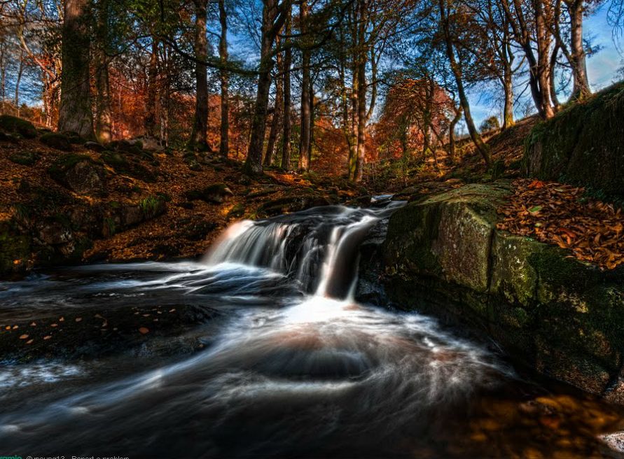
My second case is the parish church at Manor Kilbride. Except that the church is in fact nowhere near the settlement of Manor Kilbride, indeed it does not appear to be near anywhere in particular. You pass this church on the Sally Gap road - it is marked with a cross in the map below.

The magic of this place is the Shankill stream descending over rocky pools down to join the river Liffey, and the road bridge over this stream. The picture below (not my own) is almost surrealistic.
But the church - why build a church here of all places? And what a strange, almost "toy-town" building (I hope this judgement offends no-one!).

Further research reveals that there is a mound - doubtless a burial mound - just behind the church. It seems to now be part of someone's front garden. The map is the 25" to the mile version.

My third case is on the way from Hollywood cross roads towards Dunlavin. After the crossing at Lemonstown the road climbs up over what I suppose is a terminal moraine with a wonderful view as you come over the top.

The road bends to the left and, after passing a (doubtless sand and gravel) quarry on the left, you come to the magic place, marked with a cross in the map above. I have passed this place numerous times on my way to pick up materials from the builder's suppliers Liam Kennedy, and the magic intrigues me every time. The picture below is from Street View and does not, I regret, do justice to the place.

There is a mound densely covered with trees, a tiny stream between this and the road, and a grassy hill going up to a ruin (just visible in my picture). The whole site appears to be on private land, and there is no place to park, so not much chance for exploring.
The historic 25" map shows the mound, a fish-pond and reveals that the ruin is a church.

++++
My fourth case is Old Kilcullen church. From our place you head for Brannockstown, past the quaint Baptist Church there, and go straight across the dangerous cross roads where you might turn right for (new) Kilcullen. The magic location is a church on a hill, marked with a cross in the map below. This time there are no trees and no water.


It is an odd place to find a church. One would have thought a church should be near where people live and not perched upon a hill. When I first came across this place I parked the car, of course, and wandered up to the path shown to check it out. Nothing of much consequence, a church is a church, and I cannot say that this location ranks very high on my magic rating - but it is still strange.

The 25" map (above) doesn't help much, except to indicate that the site is ancient. Zooming out a bit using the older 6" map reveals another hill not too far away, the very important prehistoric site Dún Áilinne.

There is something very odd going on here! This link suggests that "...the hills Old Kilcullen and Dún Áilinne... how the symbiotic relationship between ecclesiastical and royal authority within this estate is expressed in the unusual shapes of the townlands (red borders) which ensures that the church of Kilcullen has a tenurial and symbolic stake in both of these sacred hills."

++++
My last case is also weaker than my first three. I pass the location on my way to visit an aged neighbour. Head towards Kilcullen from Ballymore: the magic place is marked with a cross. The cottage pictured below was my first focal point. There is something about this cottage that I like - it is something to do with the white painted iron fence, possibly resonating with some childhood memory.


After passing this cottage you see the church ruins on your left, several hundred yards from the road.


The 25" map doesn't show any evidence of prehistoric earthworks but does indicate several ancient monuments near the church, and interestingly a "hydralic ram" (that's a ram pump, see my previous post).

The older 6" map shows more detail (and a large "H"...) - perhaps those embankments are prehistoric, or are they simply dykes? Interesting my cottage is still there and is identified as "Stonebrook cottage".

++++
One more case could be added, but it belongs more to my son - it is the five-ways junction marked "Carnalway" in the general map above. I will leave Jonathan to supply his own emotions should he ever read this post and want to comment, but I can at least testify that there are lots of trees here and a church, again in an odd position but this time possibly because it belongs to a large estate surrounded by an stone wall.
++++
Conclusions? Is it just that I like locations where there is visual interest, especially trees, water and hills? This is certainly true. But I cannot help thinking that there is something more. And are the various churches (some in ruins so very ancient) and prehistoric earthworks just co-incidence?
Long ago in college days I stumbled across some fellow students poring over maps. I have always loved maps so stopped to talk: there were investigating the phenomenon of ley-lines. This site gives a fairly factual summary of the apparently well known St Michael ley line. You will see a number of very oddly placed churches in the pictures, one being on Glastonbury Tor. Why build churches in such odd places? So much work lugging the stones up there! We have a "church mountain" a few miles from our home: on top there is now just a pile of stones, but once it was a church and they still say mass up there every so often.
See here for a Christian perspective on ley-lines and the like. The suggestion here is that the paranormal aspects are the work of demons. I do not know what this does for my "enchanted" places - I cannot help the feeling I had when I first passed near these locations, and I am not aware of anything sinister about it?
As for those churches - maybe the building of churches was more political than anything to do with Christ? Or maybe they built the churches in these places intentionally to break the forces of evil? Or maybe it is just co-incidence that they lugged all those heavy stones up to the top of an otherwise deserted hill?
I can't say I like the ley line link - he doesn't seem to be a good representative of "Christians" and I wonder whether your post should have read "a Christian's perspective" at least!
ReplyDeleteAs to the rest of it I tend to think there is some truth there, like the other truths we gather between the lines little by little all our lives - standing out more and more clearly through the erosion of experiences as things that must be so. It is like this with the Arthurian legend - and again with the question of whether there really were dragons.
Although, taking the other side, it is interesting regarding Unicorns that supposedly their horns only became to be represented (in art, descriptions etc) as spiral after people began to sell "unicorn horns" that were really harvested narwhal tusks... So it is that the accumulation of man's wisdom on a subject may really turn out to be a vanity and no more true because so many believe!
I do think though that the following of such things isn't for us. (Here, this is "the Christian perspective" at last!) I like what Ransom says to Merlin: "It is in this age utterly unlawful. It never was very lawful, even in your day…" But that's re the following - the awareness surely is an extension of the same awareness that there is a world greater than our own right beside us! The kingdom of God is as much of a fairytale to an unbeliever.
But I know exactly what you mean about a sense of magic. I can't say I have found any places like this in Alaska so far, though I have found some really beautiful places...
As for the five way junction - I never realised it was called Carnalway! Sounds like something out of Pilgrim's Progress… Add to this the fact that it is actually a 6 way junction…!
Here are a couple of panoramas anyway. One is taken from Google streetview this evening. The other I remembered taking the photos for in 2002 - I was going to put together a VR experience of Ireland… Maybe I will go back through these photos and post some of how things were in 2002!
https://picasaweb.google.com/116087735296171686415/6WayJunction?authkey=Gv1sRgCKeQ14_HleHRAg